The current atmospheric conditions over Saxony feature a zone of labile and relatively moist air, influenced by a low pressure area over the Atlantic and a high pressure ridge, extending from the Norwegian Sea over South Scandinavia to South-eastern Europe. These conditions cause convection which leads to thunderstorms with locally intense rainfall.
Yesterday, the Weißer Schöps catchment was hit by such a convective event (see Fig. 1) with intensities of up to 30 or 40 mm between 17:00 and 19:00 Central European Summer Time (UTC+2h).

The rainfall led to an immediate water level rise at gauge Holtendorf (54.23 sq kilometre catchment), less than one hour after the onset of the rainfall. The water level went up from a mean low flow level (27 cm) and exceeded the second alert level (fixed at 200 cm) by 13 cm in less than two hours (Fig. 2). During this span of time, the discharge multiplied by factor 100.

Due to the very local character of the event, alert levels at the next gauge in downstream direction (Särichen) were not exceeded. Moreover, neighboring gauges like Schöps at Schwarzer Schöps (around 10 km air-line distance from Holtendorf) showed absolutely no signal.
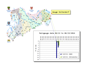
A glance at the rain gauge data underlines the strong spatial heterogeneity of the rainfield. Whereas the DWD gauge (German Weather Service) at Görlitz (approximately 1 km southwest of gauge Holtendorf) recorded around 23 mm in 2 hours, the Görlitz gauge, ran by Meteomedia (located approx. 2 km west of the DWD gauge) recorded only 6 mm in the same time interval (see Fig. 3).

